Tuesday, May 3, 2011

Hawaii

At first thought, Hawaii does not seem to relate to Seattle in any way. However, Hawaii does have similarities among each other. "The state's tropical location means warm climates, areas with high precipitation, and abundant plant and animal life." In Seattle, one can say that high precipitation is present. "Average yearly rainfall in Seattle is 36.2 inches, compared to 19.5 inches in San Francisco, 34.5 in Chicago, 39 inches in Washington, DC and 40.3 inches in New York City."


"Hwaii's eight main islands contain more than 99 percent of the state's land area and all but a handful of its people. The big island of Hawaii, at 8150 square kilometers, comprises nearly two-thirds of the state's landmass... Hawaii is near the middle of the Pacific Ocean. Honolulu, the state capital, is 3850 kilometers west of San Francisco, 6500 kilometers east of Tokyo, and roughly 7300 kilometers northeast of the Australian coast."

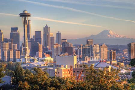
"Although the island's economies differ, tourism is important generally in Hawaii's economy more so than in most states... Tourism has become the principal growth sector of the economy, increasing its share of total island income from 4 percent in 1950 to 18 percent in 1970 and over 22 percent today. Tourism produces over $11 billion per year for the Hawaiian economy and employs more than 171,000 people, nearly 22& of all jobs." Seattle experiences tourism as well, I have traveled out to Seattle to just visit and love going there. Major attractions in Seattle are the Seattle center, Space Needle, and Seattle Aquarium. Seattle "attracts more than 8.8 million overnight visitors and contribute more than $416 million in state and local tax revenues."

Our book tells us that Hawaii has volcanoes around it. "The Hawaiian island chain is the visible portion of a series of massive volcanoes. The ocean floor supporting them is 4000 to 5000 meters below sea level. This means that for a volcano to break the water's surface, it already forms a mountain almost 5 kilometers in height." Seattle has a volcano close to it too, Mount Rainier. "Mt. Rainier is considered one of the most dangerous volcanoes in the world, and it is on the Decade Volcano list. Because of its large amount of glacial ice, Mt. Rainier could potentially produce massive lahars that would threaten the whole Puyallup River valley... The most recent recorded volcanic eruption was between 1820 and 1854, but many eyewitnesses reported eruptive activity in 1858, 1870, 1879, 1882 and 1894 as well.Although Mount Rainier is an active volcano, as of 2010 there was no evidence of an imminent eruption. However, an eruption could be devastating for all areas surrounding the volcano. Mount Rainier is currently listed as a Decade Volcano, or one of the 16 volcanoes with the greatest likelihood of causing great loss of life and property if eruptive activity resumes. If Mt. Rainier were to erupt as powerfully as Mount St. Helens did in its May 18, 1980 eruption, the effect would be cumulatively greater, because of the far more massive amounts of glacial ice locked on the volcano compared to Mount St. Helens and the vastly more heavily populated areas surrounding Rainier."


Text Sources: Textbook, http://en.wikipedia.org/wiki/Mount_Rainer, http://www.seattle.gov/oir/datasheet/Datasheet2010.pdf

Picture Sources: http://rst.gsfc.nasa.gov/Sect2/ger_volcanoes_mtrainier.jpg, http://fineartamerica.com/images-medium/1-seattle-space-needle-greg-west.jpg

Monday, May 2, 2011

The North Pacific Coast

Seattle, Washington is part of the North Pacific Coast, along with Vancouver, Canada and Portland, Oregon. "Seattle has been the ;argest city along the North Pacific Coast since its boom era of the late nineteenth century. Founded as a logging center, Seattle achieved regional dominance when it was linked to the northern U.S. transcontinental railroads... One of the great successes of the Seattle area is, of course, Microsoft. Spin-off research, along with the University of Washington's own work, has expanded the information technology, biotechnology, and healthcare sectors of Seattle's economy. In King County alone, Microsoft emplys about 16,000 people. The attraction of job opportunities at Microsoft and other high tech firms fueled in-migration, as did the growth of Seattle's cultural appeal as the center of the "grunge rock" movement of the early 1900's. Today, the Seattle metro area has grown to 3,263,497 (2006) and continues to experience substatial immigration."

Fishing is a big part of the North Pacific Coast, Our text reads "The North Pacific's cold waters were, and to an extent still are, fertile fishing grounds... Salmon has been the fish of greatest import in the North Pacific Coast for a long time. It was a major food and economic mainstay of coastal tribes before Europeans arrived and is still the principal fish caught in the region." Seattle is a great place to go fishing, Trident company ges fishing their for the fish products. I remember when I was a little girl my stepfather worked for Trident and would fly out to Seattle to go fish for them often.

Fisherman's Terminal in Seattle


Text Sources: Textbook, http://www.seattle.gov/oir/datasheet/Datasheet2010.pdf
Picture Source: http://farm3.static.flickr.com/2599/3680500969_f878129614.jpg

California

California is a great and distinctive place to live in. It has great features that you just cannot find in other states. "California evokes different reactions in people not living there. Many view California as the desirable ideal of a modern, outdoor-oriented American life-style...The reality is guided by the State's physical environment and the fact that California is home to more thatn 12 percent of all Americans. (294)" Seattle has it's distinctive features as well. It's called the rain city because of its year-round precipitation. Personally, I would like to live in Seattle because they are the opposite of California. They have as many rain days as we have summer days. Just as California attracts people Seattle attracts people in its own way, "the city of Seattle has become a commerce, culture, science and innovation in the Pacific Northwest region. Seattle lies 113 miles south of the U.S.-Canadian border and serves as a hub for travel and trasportation to Alaska, Pacific Asia, Europe, and the Salish Sea region. Surrounded by mountains and water, the Seattle area features picture-perfect views, a mild climate and abundant recreational opportunities year-round."

Unfortunately, California is dealing with a water supply crisis. "As more people choose to live in CAlifornia and its neighboring states, water demands and the cost of new projects designed to meet those demands rise. But California's water supply is limited, as is that of the entire Southwest. The region is quite close to using its entire supply." In addition, "Increasingly heavy auto use has resulted in congestion on major arteries. Los Angeles County has four of North America's five busiest freeways... In reality, Los Angeles produces only moderate amounts of pollution; little heavy industry exists, burning is carefully controlled, and strict controls govern automobile emissions." In Seattle, water conservation projects are being created as well. "Saving water partnerships utilities are now offering water conservation incentives to construction of new multifamily and commercial buildings. By incorporating these technologies your new building will use up to 30% less water."

Beautiful California...


Beautiful Seattle...


Text Sources: Textbook, http://www.seattle,gov/
Picture Sources: http://www.destination360.com/north-america/us/california/images/s/california-theme-parks.jpg, http://fabandfru.com/new/wp-content/uploads/2009/12/seattle-skyline-Main.jpg

The Southwest Border Area: Tricultural Development

Our textbook describes the southwest border as "a culture region distinguished by coexisting Spanish American, American Indian, and Northwest European American (Anglo) people. The presence of each group imbunes the region with different characteristics that, together, make the Southwest one of the most plural and transitionary American regions. From Southern California's Pacific Coast to the Texas Gulf Coast north of the Rio Grande, the Southwest Border Area parallels the U.S.-Mexico border." Seattle can relate to the Southwest Border in terms of the cultural distribution. Seattle is mainly populated by Anglo-Americans but it does have it distribution of American Indians, Hispanics, African Americans and so on. Seattle differentiates from the Southwest Border area because it does not Border with Mexico, it borders with Canada.

In terms of ethnic diversity Seattle has a White population of 394,889 people, African American population of 47,541 people, American Indian population of 5,659 people, and Hispanic population of 29,719 people. The median family income in Seattle is $85,600 and education is at a high percentage as well. the percentage of people with a B.A. or higher is 56% and High School degree is 92.5% which leaves socioeconomic disparities at a loss. Education is very important and it is encouraged throughout secondary education and post secondary education. Seattle has a great public university (University of Washington) and many four-year community colleges to help attain a degree.

Text Sources: Textbook, http://www.seattle.gov/oir/datasheet/Datasheet2010.pdf

The Empty Interior

"The Empty Interior is a land of stark contrasts where aridity and lushness intermingle across wide desert valleys and high, rugged mountains" (252). "Much of the empty interior has a precipitation pattern that leaves it arid or semiarid. The dryness becomes increasingly apparent toward the region's southern zones. Nearly all of the area in the United States that can be classified as desert is found in the Empty Interior or in the Southwest's borderlands" (256). For Seattle, this is not a problem, Seattle is not considered a desert city. I have personally been there and it is more cool than dry. When it is not raining in Seattle the weather is nice and cool, and the sun is not scalding hot or too dry on the environment.

Seattle, has a wildlife sanctuary program that helps promote wildlife preservation.
Parks' Wildlife Sanctuary Policy articulates Parks' commitment to sustain habitats for a wide variety of wildlife and outlines steps Parks will take to create and manage wildlife sanctuaries for these species:
  • Local populations of federally endangered or threatened species
  • State Priority Species or Species of Concern
  • Locally important species with declining populations
The Empty Interior has a large amount of mormons. "Mormons still have a substantial impact on the Empty Interior. Of the region's roughly 14.5 million people, about one in seven are Mormon's... Substantial numbers of Mormon's also live in Nevada, northern Arizona, and western Wyoming" (262). "All major religions are represented in the greater Seattle area. In addition to various Protestant, Roman Catholic, and Eastern Orthodox churches, there are numerous Jewish synagogues, Buddhist temples and Islamic mosque."

"The great variety and appeal of the Empty Interior's scenic wonders attracts millions of visitors each year" (267). Seattle is a big attraction place for the state of Washington, it attracts many people each year. "The Seattle-King County area attracts more than 8.8 million overnight visitors annually who spend $6.9 billion and contribute more than $416 million in state and local tax revenues."


Text Sources: Textbook, http://www.seattle.gov/, http://www.seattle.gov/parks/wildlife/sanctuary
Picture Source: http://www.corporateservices.noaa.gov/facmd/BMB%20Websites/Seattle%20Webpages/Seattle.jpg

The Great Plains and Prairies

Our text reads, "Historian Walter Prescott Webb suggested in his book The Great Plains that the great, continuous grassland located astride North America's center were so unlike the home regions of Northwest European settlers that before they could live in the Great Plains, they had to develop new crops, new land-use patterns, and new technologies. The agricultural crops and settlement patterns they carried with them from Europe were inappropriate. European settlers encountered several environmental surprises on the Great Plains. Rainfall in the grasslands was far less than in the forested East, and the Plains' western margins were much drier. Violent storms accompanied by high winds, hail, and tornadoes were common. Blizzards' wintery blasts intensified the season's worst cold and mounded snow into immense drifts. In summer, the soil was parched by hot, dry winds, sometimes carrying dirt away in huge, billowing clouds of dust. Small, intermittent streams were the only source of water able to support the region's sparse trees. Farmers newly arrived from eastern states had to adjust. No longer were plentiful water for crops and animals and ample wood for building, fencing, and heating available. They faced conditions on the Great Plains for which they had little realiable information."

Seattle on the other hand, is different from the Great Plains in terms of climate. There are about six weeks of summer in Seattle and an adequate amount of rainfall for the rest of the year as opposed to the little rainfall in the Great Plains, and the hot dry winds in the summer. Due to the climate in Seattle, they have a very good chance for a successful agriculture. There is enough land and technology to grow crops without much problem in Seattle. Luckily, Seattle doesn't experience extreme weater like the 20-year drought cycle that the Plains once experienced. In terms of climate Seattle is pretty stable.
Text Source: Textbook

The Agricultural Core

Our text tells us that "Adequate rainfall with little annual variability, coupled with ample growing seasons, makes the region idel for growing corn and other mid-latitude agricultural crops." In addition, "The agricultural core's mix of environmental characteristics-rainfall, length of growing season, relief, and soils-allows certain kinds of farming to excel." This relates to Seattle, Washington because there is an adequate amount of rain in Seattle which helps the farming industry.
"Washington State Department of Agriculture has developed an agricultural land use geodatabases to assess the effects of agricultural production on Washington's natural resources. The geodatabase can store, query, and manipulate geographic information and spatial data used to identify agriculture land use in state. WSDA crop data is classified by several categories: 1. general crop group (berry, cereal grain, orchard, vegetable, etc.); 2. crop types (blueberry, wheat, apple, potato, etc.), and 3. irrigation method (center pivot, drip, rill, none, etc.). Traditional agriculture land use data provides only broad use definitions limited to distinctions made between row crops and pastrure."
"The future of farming is a statewide strategic plan for Washington agriculture submitted to the Legislature and the Governor in February 2009.
The future of farming identifies five broad strategies for keeping agriculture viable:
  1. Make agriculture a priority. Farming needs to be a priority for the state's citizens and lawmakers.
  2. Eliminating regulatory barriers. Complex local, state, and federal regulations that threaten the competitiveness need to be assessed and reformed.
  3. Protect resources. The availability of productive and affordable land, water, labor and energy resources is essential.
  4. Strengthen support services. Future competitiveness requires strong support services in education, transportation, research and development, processing, marketing, and more.
  5. Harness emerging opportunities. Agriculture must recognize and tap into emerging opportunities.


Text Sources: Textbook, http://agr.wa.gov/
Picture Source: http://media.cleveland.com/business_impact/photo/seattle-times-farm-growthjpg-83a44fc5e90bbf69_large.jpg